Home
Museums

KUMEYAAY MAPPING PROJECT MAPS Old Maps Southern California Baja Mexico fotos Indian Reservations Mapas satellite imagery and Kumeyaay historical facts about Kumeyaay history 1769 1798 1836 1842 1852 1700s 1800s 1900s 2000s turn of the century 19th 20th 21st century Indian maps. Maps and history by Mike Connolly Contributed by Campo Band of Kumeyaay Indians WebSite

Kumeyaay Maps Historical
Kumeyaay Map
Click on Kumeyaay map thumbnails for larger picture.

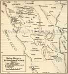
KUMEYAAY MAPS DETAIL TRIBAL HISTORY

The Mike Connolly Miskwish San Diego County historical tribal Kumeyaay mapping projects are featured in the Campo-kumeyaay History section and detail Indian history tribal homelands and facts about Southern California first nations of desert, mountain, coastal, river Indians and how today's current California Indian reservations were established in southwest United States.

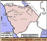
• Kumeyaay Territory when Spanish Landed, 1769
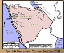
• Spanish Mission Lands Expand into Kumeyaay homelands, 1798
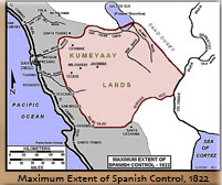
• Maximum Extent of Spanish Control, 1822
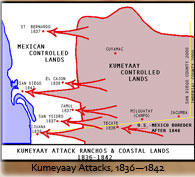
• Kumeyaay Attack Indigenous Ranchos and Coastal Territory, 1836-1842
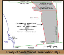
• Kumeyaay Reservation Negotiated, Treaty of Santa Ysabel, 1852 (United States and the Nation of the Dieguino Diegueño Indians)
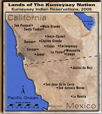
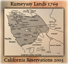
• Lands of the Kumeyaay Nation, 2005

MAP OF ALL SAN DIEGO NATIVE AMERICAN INDIAN CASINOS IN SOUTHERN CALIFORNIA

INDIAN CASINOS MAP

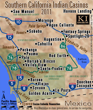
SOCAL Casino & Tribes 2012

DETAILED MAP OF SOUTHERN CALIFORNIA & MEXICAN INDIAN TRIBES:

Kumeyaay Map
Mike Connolly Miskwish, Campo Kumeyaay Map
details all the 2005 Indigenous Southern California Indian tribes, the Native American Indian reservations rancherias ranchos ejidos of the greater Southern California area and northern Baja California, Mexico, and contrasts them with the Indigenous Kumeyaay territory of 1769.


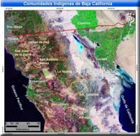
ADESU.ORG indigenous website includes a detailed satellite map that shows the US-Mexico border area including Golfo de California, Gulf of California, San Isidoro, Kiliwas, Santa Catarina, Ensenada, La Huerta, Cucapa, San Antonio Necua, San Jose de la Zorra, Juntas de Neji, Tijuana, Mexicali, Calixico, San Diego, Océano Pacifico, Pacific Ocean geographical areas from outer space topographical high-altitude planetary perspective. NOTE: The ADESU website has been deleted from the internet.

HISTORICAL INDIAN MAPS:

DIEGUENO MAP Early 1800s 1900s 1910s 1930s 20th Century historical maps:


HISTORICAL DIEGUENO MAP 1920s
old antique map unique spellings of Mexico Diegueño Yuman tribes Mexican early 1900s, 1920s, including Jamul, San Diego, Tecate, Campo, Tijuana, Yuma, Tanama, Kwitark, Jacume, Cerro Centinela, Kamia, C. Prieto, Kwatl Kumiyai, Kwiñitl, Sierra de los Cocopas, Cocopa, C. Borrego, Rio Colorado Channel, Papago, Kwijas, Las Juntas, Niji, Agua Hechicera, El Compadre, Mishkwish, Santa Clara, Jamatay, Descanso, San Jose, Guadalupe, San Miguel, Kwatl Kumiyai, Jat'am, Agua Hervidors, Campo Nacionel, Ensenada, Santa Catalina, Sierra de la Tinaja, Sierra Pinto, Arroyo Grande, Cerro Borrego, Sierra de San Felipe, Valle de San Felipe, Sierra de San Pedro Martir, Arroyo Leon, P. del Diablo, Santo Tomos, San Vincent, San Telmo, Santa Domingo, San Pedro Martir, Juigrepa, San Quintin.

KILIWA PAI PAI MAP Early 1900s 1910s 1930s:


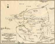
HISTORICAL KILIWA PAIPAI 1920s
old antique map unique spellings of Mexico Yuman Indian tribes Mexican early 1900s, 1920s, including Mesa Zone, Valle de la Trinidad Jasi(G), Cerro Colorado Kwiniel Wey, Wey Ijt, Zone of Rugged Cañons, Cuap Wey, Chipa Wey, Arroyo Carrisito, Agua Caliente, Jacopin, Jupap Wey, Jupaja, Ucha Wey, Wey Mijak, Jewiluja Wey, Jel Jumkwinep, Colwey, San isidoro Japoknian, Isicha'a, San Antonio del Valle, Nakipa, Wey Cojo, Tuwaloniwey, Jeljumkwinep, Jewiluja Wey, El Paso de San Matias, Jeji Chuwilu, San Martias Spring Jejija, San Felepe Desert, Selewalo, Kay Kesiay, Muwa Wey, Jankilawa, Kay Sipukwin, Juigrepa, Esperanza Cañyon Cuchiwa.


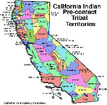
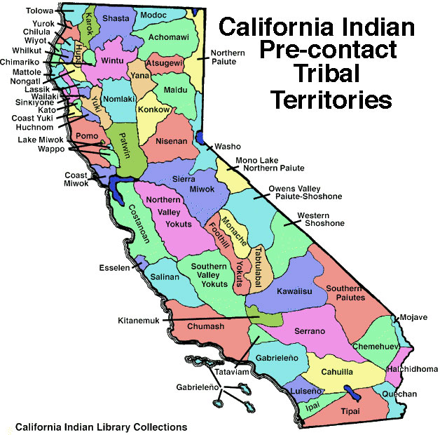
HISTORICAL PRE-CONTACT MAP
of the California tribal ancestral territories (courtesy of California Indian Library Collections).

KUMEYAAY CALENDAR • KUMEYAAY NEW YEAR:


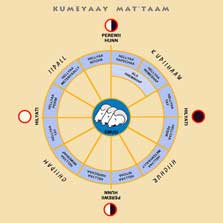
Mike Connolly Miskwish, Campo Kumeyaay Calendar

KUMEYAAY MAT'TAAM means Kumeyaay Year
This Native American California Indian calendar is a contemporary interpretation of the traditional Kumeyaay calendar.  Historically, the Kumeyaay calendar was flexible and adaptive to changing conditions.

CURRENT KUMEYAAY BANDS:

UNITED STATES Southern California Kumeyaay bands:

Sycuan Band of the Kumeyaay Nation
Mesa Grande
Viejas Band of Kumeyaay Indians
Barona Band of Mission Indians
Capitan Grande
Santa Ysabel Band of Diegueño Indians
San Pasqual Band of Indians
Inaja Cosmit
Ewiiaapaayp Band of Kumeyaay Indians Cuyapaipe
Manzanita
La Posta
Jamul Indian Village
Campo Band of the Kumeyaay Nation

BAJA CALIFORNIA MEXICO Kumeyaay Kumiai bands:

San Jose de la Zorra
San Antonio Necua
La Huerta
Juntas de Neji,
Santa Catarina (Kumeyaay Paipai Pai-Pai)

Kumeyaay Documentaries
KUMEYAAY DOCUMENTARIES Indigenous peoples of California Native American
Indian documentary series features SAN JOSE DE LA ZORRA Kumeyaay Indian village, Baja California, Mexico. Also, SANTA CATARINA, SAN ANTONIO NECUA and JUNTAS DE NEJI. KUMEYAAY.INFO showcases the professional photography and journalistic documentation virtual tours of village inhabitants rancherias ranchos Indigenous lifestyles in the tribal ejidos of Baja, environmental portraits, habitations and pictures of their traditional California Native American arts and crafts. Los indios indígenas de las fotos documentales de la forma de vida del photojournalism de México representan películas.

THE INDIGENOUS TRIBES OF GREATER SAN DIEGO COUNTY MAP:

LUISENO Luiseño Indian bands:

La Jolla, Pala Band of Mission Indians, Rincon San Luiseno Band of Mission Indians, Pechanga Band of Luiseno Indians, Pauma Yuima...

CAHUILLA CUPENO bands:

Los Coyotes Band of Mission Indians Cahuilla Cupeno Indians Cupeño, Warner Springs, CA, Los Coyotes Indian Reservation pictures

COCOPAH Cucapa:

Cocopah Indian Tribe, Somerton, AZ
Cucapa Indian village, El Mayor, Baja California, Mexico

QUECHAN:

Fort Yuma Indian Reservation, Winterhaven, CA


NEARBY CALIFORNIA INDIAN RESERVATIONS AND THEIR PEOPLE
:
(Click HERE or on the linked page's thumbnail to enlarge map file).
The Indians of San Diego County, DOLAN H. EARGLE JR.

"Four tribal groupings make up the indigenous Indians of San Diego County: The Kumeyaay-Diegueño, the Luiseño, the Cupeño, and the Cahuilla."

Includes detailed information and first-hand accounts about:

BARONA Indian Reservation
SYCUAN Indian Reservation
CAPITAN GRANDE Indian Reservation
VIEJAS Indian Reservation
JUMAL Indian Village
EWIIAAPAAYP Indian Reservation
CAMPO Indian Reservation
MANZANITA Indian Reservation
INAJA-COSMIT Indian Reservations
SAN PASCUAL Indian Reservation
SANTA YSABEL Indian Reservation
MESA GRANDE Indian Reservation
AJACHEMEM NATION, JUANENO Indians
LUISENO Indians
PALA Indian Reservation
LA JOLLA Indian Reservation
RINCON Indian Reservation
PAUMA-YUIMA Indian Reservation
PECHANGA Indian Reservation
SOBOBA Indian Reservation
SAN LUIS REY BAND OF MISSION INDIANS
PEOPLE OF THE MOJAVE DESERT and COACHELLA VALLEY and COLORADO RIVER
CHEMEHUEVI (Southern Paiute) CHEMEHUEVI Indian Reservation
29 TWENTY-NINE PALMS Indian Reservation
KITANEMUK TRIBE OF TEJON INDIANS
SERRANO and VANYUME
SAN MANUEL Indian Reservation
CAHUILLA Indian Reservation
RAMONA Indian Reservation
SANTA ROSA Indian Reservation
LOS COYOTES Indian Reservation
TORRES-MARTINEZ Indian Reservation,
AUGUSTINE Indian Reservation
CABAZON Indian Reservation
AGUS CALIENTE Indian Reservation
MORONGO Indian Reservation
CUPENO Indians.
Terms of UsePrivacy StatementSite Map
Kumeyaay Indians Home
About UsMission StatementPress KitContact Us