KUMEYAAY MAP
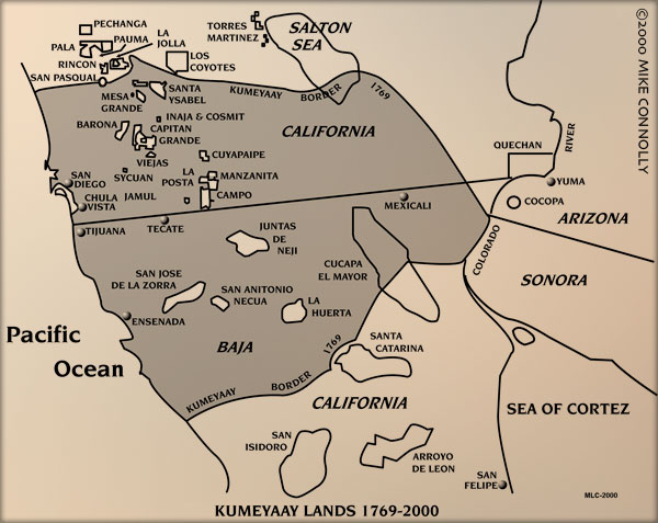
The above Mike Connolly historical "Kumeyaay Lands 1769-2000" map picture details the 2005 Indigenous California Indian tribes of the greater Southern California area and northern Baja California, Mexico, the Native American Indian reservations, and contrasts them with the Indigenous Kumeyaay territory of 1769 (gray area).
The above area is part of a 24- by 36-inch historical poster map which details the ancestral Kumeyaay territory and the Treaty of Santa Ysabel, 1852.
The Treaty of Santa Ysabel marked the entry of the northern portion of the Kumeyaay Diegueno Nation into the United States. Clan leaders from as far as Jacumba and San Diego met at Santa Ysabel to sign the treaty with the United States Indian agent, O.M. Wozencraft.
Although not ratified by the U.S. Senate, the agreements of the treaty served as the basis for future settlements in land claims and other disputes. The United States recognition of the Kumeyaay people as a nation within a nation is carried forward today under the concept of Tribal Sovereignty.
Five more Mike Connolly Campo Maps may be accessed from KUMEYAAY.INFO.
These five historical maps detail Kumeyaay points of history:
• The arrival of the Spanish 1769
• The Spanish expansion into Kumeyaay Indigenous territory 1798
• The maximum extent of Spanish control 1822
• The Kumeyaay attacks on the Spanish to regain their lands 1836-1842
• The Treaty of Santa Ysabel 1852

MAPS of KUMEYAAY HISTORY 1769 - 2005 highlight Kumeyaay points of history, the arrival of the Spanish, the Spanish expansion into Kumeyaay Indigenous territory, the Kumeyaay wars with the Spanish and Mexican invaders to regain their Indigenous tribal lands and stop abusive agression, the Treaty of Santa Ysabel, the California Genocide and California Mission periods, including the current Kumeyaay bands of Native American Indians in Southern California and northern Mexico.
|
